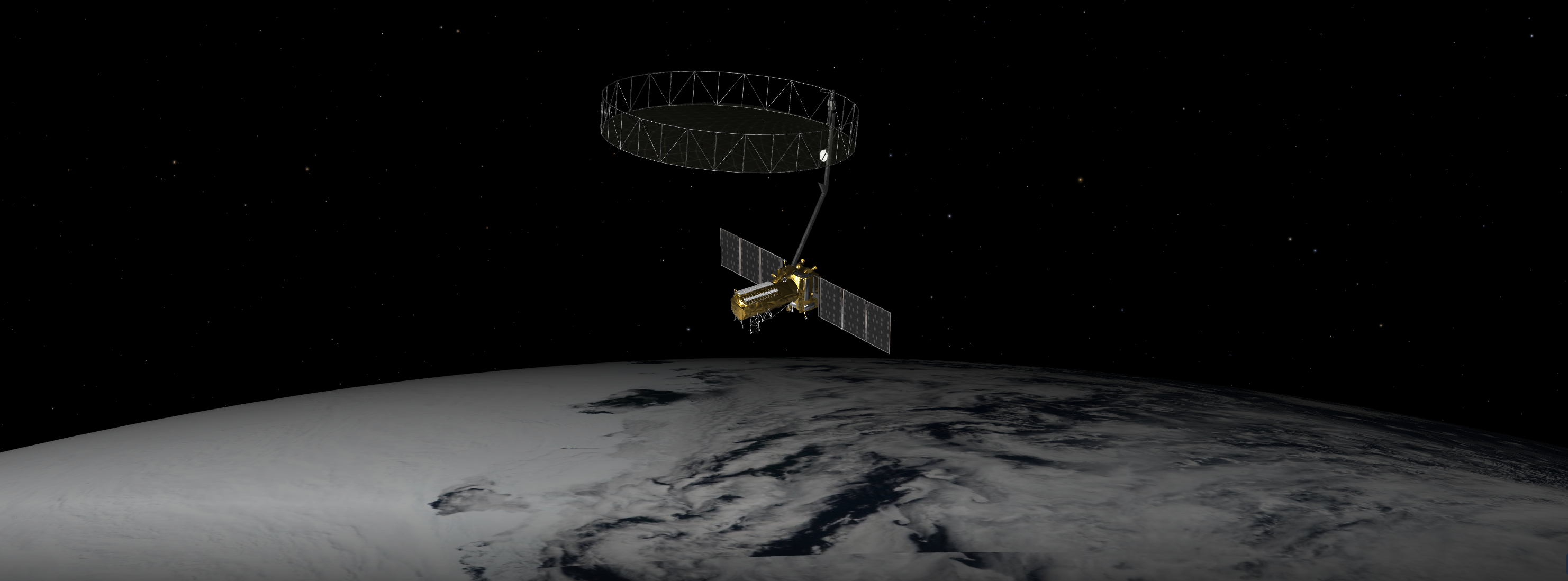
The NASA-ISRO Synthetic Aperture Radar, or NISAR satellite, will use advanced radar imaging to map the elevation of Earth's land and ice masses 4 to 6 times a month at resolutions of 5 to 10 meters. It is designed to observe and measure some of the planet's most complex natural processes, including ecosystem disturbances, ice-sheet collapse, and natural hazards such as earthquakes, tsunamis, volcanoes and landslides. Under the terms of the agreement, NASA will provide the mission's L band synthetic aperture radar (SAR), a high-rate telecommunication subsystem for scientific data, GPS receivers, a solid-state recorder, and a payload data subsystem. ISRO will provide the satellite bus, an S band synthetic aperture radar, the launch vehicle, and associated launch services.

NET July 30.
NET July 16.
NET July 5.
NET June 18 per NOTAMs, TBC.
NET June.
Geosynchronous Satellite Launch Vehicle Mark II (GSLV Mk II) is the largest launch vehicle developed by India, which is currently in operation. This fourth generation launch vehicle is a three stage vehicle with four liquid strap-ons. The indigenously developed cryogenic Upper Stage (CUS), which is flight proven, forms the third stage of GSLV Mk II. From January 2014, the vehicle has achieved four consecutive successes.
The Indian Space Research Organisation (ISRO) is the space agency of the Government of India headquartered in the city of Bangalore. Its vision is to "harness space technology for national development while pursuing space science research and planetary exploration."
INFO WIKI
Missions will study everything from water on the Moon to the transformation of our universe after the big bang and ongoing changes to Earth’s surface. With 2024 receding into the distance, NASA’s Jet Propulsion Laboratory is already deep i…

Set to launch within a few months, NISAR will use a technique called synthetic aperture radar to produce incredibly detailed maps of surface change on our planet. When NASA and the Indian Space Research Organization’s (ISRO) new Earth sate…
A Q&A with the lead U.S. scientist of the mission, which will track changes in everything from wetlands to ice sheets to infrastructure damaged by natural disasters. The upcoming U.S.-India NISAR (NASA-ISRO Synthetic Aperture Radar) missio…

HELSINKI — India’s space agency is planning 10 orbital launches in 2025 along with a debut commercial launch, potentially taking the country’s launch activity to double figures for the first […] The post India eyes record year for space w…

A joint Earth science mission between NASA and its Indian counterpart is now scheduled to launch as soon as next March after being delayed to repair its main radar antenna. The post NISAR planned to launch in March 2025 after antenna repa…
'Symphony In The Stars' is the first of two dedicated missions on Electron to deploy a single spacecraft to a 650km circular Earth orbit for a confid…
A batch of 27 satellites for the Starlink mega-constellation - SpaceX's project for space-based Internet communication system.
HawkEye 360 is a a space-based civil global intelligence satellite network using radio frequency (RF) technology to help monitor transportation acros…
A batch of 27 satellites for the Starlink mega-constellation - SpaceX's project for space-based Internet communication system.
This is a Crew Dragon flight for a private company Axiom Space. The mission will carry a professionally trained commander alongside three private ast…
Dedicated rideshare flight to a sun-synchronous orbit with dozens of small microsatellites and nanosatellites for commercial and government customers.
Project Kuiper is a mega constellation of satellites in Low Earth Orbit that will offer broadband internet access, this constellation will be managed…
A batch of 27 satellites for the Starlink mega-constellation - SpaceX's project for space-based Internet communication system.
Ku- and Ka-band geostationary communication satellite for China Satcom at 92.2° East, replacing ChinaSat 9.
Unidentified payload for the Russian military.

